


The Trans Caucasian Trail. What it is all about.
The Trans Caucasian Trail is being developed by the Transcaucasian Trail Organization. The idea is to put together a 3000 kilometer trail system using existing trails and then developing connecting trails to make a continuous trail network through Georgia, Armenia and Azerbaijan.
Note: This blog is about introducing the readers to the hiking opportunities in the Caucasus. The Trans Caucasian Organization and Caucasus Trekking websites can provide you with the detail. Take note that the TCT will continue make changes to the route depending on circumstances.
CONTENTS
- Working on The Trans Caucasian Trail
- Hiking the Trans Caucasian Trail
- Tips for Hiking The Trans Caucasian Trail
- Georgia
- Armenia
- Hiking The Best Of The Trans Caucasian Trail
Working on The Trans Caucasian Trail
My first experience on the TCT Volunteering was in July 2021 for 9 days to work on the trail in Brili, Racha. The 9 days was spent camping out in the deserted village of Brili. Each day we would head out to the trail to cut fallen trees, brush the trail, divert flowing water with the aim to make it easier for future hikers.
It was a fantastic experience and feeling to be able to help establish the trail, working along side Georgian and International volunteers. My version of giving back after the many kilometers I have done on trails elsewhere.

Hiking the Trans Caucasian Trail
In August 2021 I hiked on the TCT from the Samegrelo Mountain Range in Western Georgia to Oni in Racha then from Oni to Meghri on the Armenian/ Iranian border in June/July 2022.
I solo hiked both parts, wild camping the majority of the time and would stay in a guest house or campground such as Cross Way Camping or a hostel such as the Dilijan Hikers Hostel every so often to rest, wash, resupply and recharge my navigation devices.
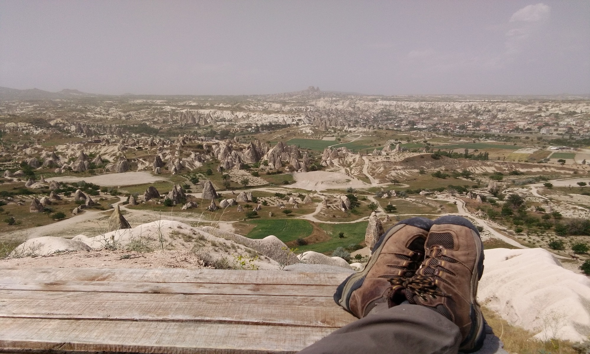
Hiking the full length (1800kms) of The Trans Caucasian Trail from Anaklia, Georgia on the Black Sea to Meghri on the Armenia/Iranian border exposes you to a multitude of different terrain and environment from the High/Low Caucasus’s, Gegham Mountains, the near desert in Southern Armenia to the forested areas in both countries.
Tips for Hiking The Trans Caucasian Trail:
Carry secateurs: There are numerous sections of the trail in both countries that are overgrown with brambles, stinging nettles and bushes which can make it a challenge to hike through, ripping your clothes and skin to shreds. I would suggest carrying a pair of garden secateurs to cut your way through. I made the mistake of leaving the pair I had in Georgia behind thinking that the Armenian TCT would be more worn in. It wasn’t. At the moment there are insufficient hikers on the trail to keep it open.
Navigation: Be well aware that there are many sections of the trail that only exists as a line on your navigation device i.e. there are no red/white track blazes and no definitive trail. I used Mapsme for the entire hike. I downloaded the trail in kml onto Mapsme.
On the ground there are multiple animal trails and jeep tracks going in all directions so it is very easy to discover that you are going in the wrong direction very quickly. Unfortunately you will find yourself constantly looking at your navigation device to make sure you are on the trail.
Water Purification: In the high alpine regions in both countries water is available but beware there is also a lot of livestock that is polluting most of the water sources. Which if you haven’t found a natural spring will necessitate the boiling, filtering or treating the water with tablets.
Most lakes are basically large animal water troughs.
Dogs: By the end of this years hike I was well and truly over the overly aggressive packs of Sheppard’s dogs. I tried my best to avoid the herders camps where ever possible, (difficult in the alpine areas as they invariably located along the trail) but a couple of times there was no choice but to run the gauntlet and hope for the best using my hiking pole as a deterrent.
I would try and hike as far as 500 meters plus away from the herders camps and rejoin the trail further on.
Georgia
Samegrelo to Oni
The TCT has on its website limited information for the Georgian section of the TCT. This will change. At present the information available is for the Upper Svaneti region. Further trail information can be obtained from the Caucasus Trekking website for gpx/kml routes to infill the Upper Caucasus region.
If you wish to hike the Oni to Ninotsminda section you will need to contact the TCT for the trail gpx, which will depend on whether they are ready to release it.


Oni to the Georgian/Armenian border
The trail from Oni to the Georgian/Armenian border crossing at Ninotsminda goes through a variety of terrain, from forest to alpine to forest (logging areas) back to alpine regions in the Lower Caucasus. The alpine terrain continues across the border into Armenia through to Lake Arpi which is the official start/finish of the Armenian TCT section of the trail.
At present the Georgian section from Oni to Ninotsminda is still being developed by the TCT trail builders.
Take note: Between Samegrelo and Oni, Mestia is about the only place you will find gas canisters and the best place to resupply. There is little to no other resupply points until Oni. Most villages do not have a store and if they do there is little in the way of hiking food available. Your other option is to stay or eat at Guest Houses along the way.
There are few sources of resupply and the ability to recharge your power bank/navigation device, especially between Speti and Zanavi. To resupply and recharge I hitched hiked from Zavani to Borjomi.


Armenia
Lake Arpi to Gegham Mountains
Crossing the border into Armenia from Georgia at Ninotsminda was very easy. I even asked the border officials if they could fill my water bottle.
From the border I hiked into the village of Bavra and found a Supermarket to buy more provisions. Fortunately I had changed some money into dram in Tbilisi before leaving as there is no facility to obtain any local currency or an Armenian sim in Bavra.
Continuing on from Bavra, I hiked further south through to the next village of Tavshut (Which also has a supermarket) and 1 kilometer past to intersect the Armenian TCT trail.
To obtain a Armenian sim I hitched hiked the next day to Gyumri a larger town further south and well off the trail to use an ATM and buy a sim. Viva sim has better coverage than Beeline.
Hitch hiking is very easy in Armenia, so it didn’t take long to hitch hike back to the TCT trail to continue further east.


Gegham Mountains to Meghri
The Gegham Mountains is the longest remote section of the Armenian TCT. Starting from Lchashen it can be 5-7 days later before you reach a another reliable source of provisions in Shatin.


Hiking The Best Of The Trans Caucasian Trail
I have been asked a couple of times by other thru – hikers what were the best parts of the trail for me.
So here goes. This is my opinion. If you are limited in time but want to cover as much of the trail as possible I would do the following:
Samegrelo to Ghebi (Kms unknown)
Zavani to Ninotsminda (Kms unknown)
Kurtan to Dilijan 100.3kms approximately
Dilijan to Jermuk 350 kms approximately
Shamb to Meghri 170 kms approximately
The above suggestions give you a good overview of the terrain in the Caucasus and removes most of the road walking and long days of hiking through rolling hills and alpine farmland.
This can work either direction North to South, or South to North depending on the time of the year. I cant give approximate hiking days as everyone hikes at a different pace.
I receive no benefits from any of the links in this post. This is purely for your benefit.
One Reply to “Hiking The Trans Caucasian Trail”